
The Federal Emergency Management Agency released new maps on its website this month, revealing more New Yorkers are at risk of flood than previously thought. The maps add to the accumulating pile of confusing and often frightening information Red Hook residents have to contemplate as they recover from the damage inflicted by Hurricane Sandy and decide how best to gird against future floods.
The new maps, called preliminary work maps, show that 70,000 buildings in New York City, including many in Red Hook, will have to be elevated by several feet, or their owners will face higher flood insurance costs. About 400,000 New Yorkers are shown to be living in the 100-year floodplain, meaning they face a 1% chance of flood each year, compared to just 218,000 people and 36,000 buildings identified as facing that risk in FEMA’s previous maps.
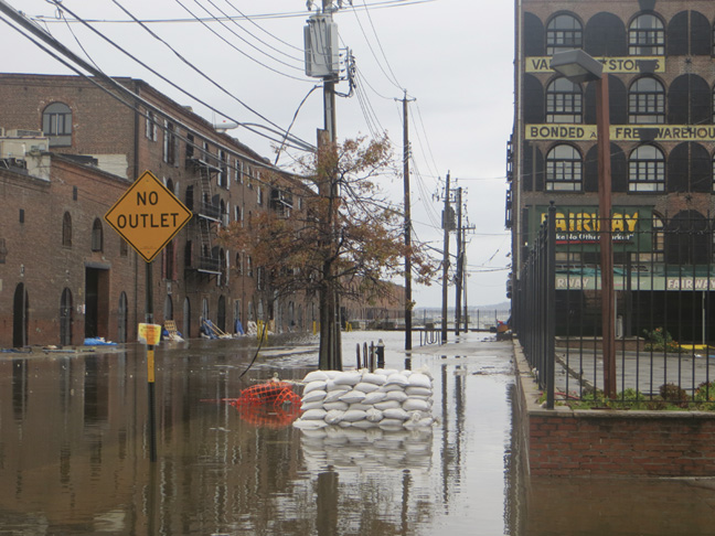
Red Hook in high hazard zone
Most of Red Hook is within the AE zone, the second-most hazardous out of FEMA’s four lettered zones, meaning that the area is within the floodplain but waves would not be expected to top three feet. But the neighborhood is bordered by a VE zone, the most dangerous category, which indicates that the water adjoining Red Hook may rise to waves above three feet in the event of a flood.
The maps, which incorporate information from a study FEMA began before Hurricane Sandy, replace the previously released Advisory Base Flood Elevation information as the best available flood-risk data. But the latest maps are not the final product. They are merely an update on FEMA’s progress toward developing Flood Insurance Rate Maps (FIRMs), due to be released in 2015. The maps are also historical, meaning that they represent the situation as it is now, but do not attempt to anticipate future events – such as rising sea levels.
“FEMA flood maps are a reflection of the reality people have to adjust to,” says Ron Shiffman, a professor at Pratt Institute’s School of Architecture and the co-founder of the Pratt Center for Community Development. Pratt’s Programs for Sustainable Planning and Development is hosting several studios, classes, and open workshops this summer dedicated to Recovery Adaptation Mitigation and Planning (RAMP). Students, faculty, and experts will attempt to discover architectural and infrastructural means to lessen the vulnerability of coastal communities.
On July 31 and August 1, the program will host a workshop entitled “Coastal Community Resilience for Residents,” to be given by the National Disaster Preparedness Training Center from the University of Hawaii. The Center will discuss the roles of community leaders and residents during and after a disaster. The time and location have not yet been determined.
Shiffman insists, “We can stop the water.” To accomplish this, he identifies two alternatives to FEMA’s standard prescription to elevate the building: dry-proofing, which prevents water from entering a building, and wet-proofing, which permits water to pass through causing minimal damage.
While acknowledging that dry-proofing is “not an option for every home,” Shiffman suggests his solutions are more realistic for Red Hook than FEMA’s. “There are a lot of idiosyncrasies in Red Hook that FEMA’s not aware of,” he says, pointing to the area’s mixed-use buildings as one such relatively unique feature.
Shiffman and the other participants in Pratt’s program aren’t the only people striving to come up with solutions suited to the particular needs of Red Hook. The Red Hook Flood Mitigation Google group manages a website that features an events calendar, a small directory of contacts, and a resource center, all stocked with information about the issues and options facing residents as they recover from the hurricane. According to members, the group was formed by residents concerned by the lack of information and guidance available in the aftermath of the storm. They hope the site will eventually serve as a medium to dialogue with and request information from city planners.
Bloomberg predicts worse
One man claims to have found the solution to some of Red Hook’s woes—Mayor Michael Bloomberg. He presented his plan to protect New York from future floods, hurricanes, and other natural disasters at the Brooklyn Navy Yard on June 11. Calling the fight against climate change “a battle that may well define our future for generations to come,” Bloomberg estimated that “by mid-century up to one-quarter of all of New York City’s land area, where 800,000 residents live today, will be in the floodplain.” That is about twice the number of people identified as at risk in FEMA’s new maps.
Slides accompanying the mayor’s speech portrayed a city armored against rising sea levels and extreme weather by sand dunes, surge barriers, and levees. The proposals, which are detailed in a 438-page report called “A Stronger, More Resilient New York,” are the result of months of effort by the Special Initiative for Rebuilding and Resiliency (SIRR) and the latest product of PlaNYC. The ambitious plan will extend far beyond the conclusion of the mayor’s term in office, and cost at least $20 billion.
In the Brooklyn-Queens Waterfront—an area that includes Red Hook, Gowanus, DUMBO, Sunset Park, Williamsburg, Greenpoint, and Long Island City—the report warns of the potential dangers of storm surge – a major cause of damage during Hurricane Sandy – brought about by sea level rise and increased precipitation. Acknowledging the unique complications posed by Red Hook, the plan calls for an international competition to design an “integrated flood protection system,” which could include temporary or permanent changes, for the area. It also prescribes better transportation for the neighborhood, by creating “a new connection between Red Hook and the rest of Brooklyn at Mill Street” and shortening the bus trip between the Red Hook Houses and the subway.
City wants quick action
According to the plan, the City hopes to create a $1.2 billion incentive program to encourage owners of buildings within the floodplain to “make resiliency investments” in their homes and businesses, provided it can gather the necessary funds. The money would be distributed among the boroughs in proportion to the amount of flood-vulnerable buildings within them, with some funds reserved for 1-to-3 family homes and affordable housing developments.
Flood insurance a major issue
The report calls on FEMA to produce maps faster and with more oversight, and to ensure that more people are aware of the dangers the maps illustrate. To assist in the achievement of the latter goal, the City plans to launch its own campaign, through social media and ads on the subway and radio, to educate New Yorkers about the importance of having flood insurance.
Likely hoping to counteract the rise in flood insurance premiums that many people—especially those newly placed in the floodplain—will eventually face as a result of the maps, the plan proposes several methods of bending FEMA policy to better suit New York City residents. The City plans to collaborate with FEMA in the production of specific flood-protection standards and certifications for urban buildings. It will also push the agency to offer higher deductibles for residential policies, develop “a system of insurance premium credits” to reward property owners who take action to reduce their flood risk, and to recognize mixed-use buildings as a distinct category.
FEMA currently classifies any building with less than 75% residential occupancy as non-residential, qualifying it for flood-proofing certification without elevating if it takes other approved flood-proofing measures. The plan contemplates joining FEMA’s Community Rating System (CRS), which offers incentives for communities to do more to mitigate their flood risk than is required of them by the National Flood Insurance Program (NFIP). Joining the CRS program might reduce flood premiums, but it would also require the City to more effectively police building code violations.
Bloomberg’s plan eschews subsidizing any flood insurance policies. The Biggert-Waters Flood Insurance Reform Act, passed by Congress last year, eliminated subsidies on new federal flood insurance policies and instituted a system to phase out subsidies on existing policies. Subsidies to be removed include those on policies for businesses, second homes, and properties that have suffered severe repetitive loss. The rates of these policies will rise by 25% each year until they accurately reflect the properties’ flood risk.
According to the SIRR report, “the impact of Biggert-Waters will be particularly severe for policyholders in New York who live in buildings constructed before the City first adopted FEMA’s FIRMs in 1983 and who, therefore, were entitled to heavily subsidized premiums.” These and other policyholders placed in a higher flood risk zone by FEMA’s 2015 FIRMs than in past maps will see their premiums rise as their subsidies are phased out over a five-year period. This means that for many in Red Hook and beyond, the full extent of flood insurance costs will not be seen until 2020.